
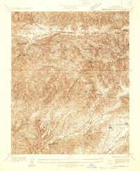
1930 Map of Ravenna
USGS Topo · Published 1930About this map
Southern Pacific rails follow the winding path of Soledad Canyon on this 1930 advance sheet, providing a primary transportation link through the mountains of the Angeles National Forest. The settlement of Ravenna and nearby Acton serve as focal points for local activity, supported by landmarks like the Acton Sta and Acton Sch. The landscape is defined by a series of family-owned homesteads and agricultural operations, including Jones Ranch, Nelson Ranch, Fryer Ranch, and the Mc Carthy Ranch. These early twentieth-century holdings, along with the Ravenna Poultry Farm, reveal a rural economy dependent on the narrow corridors of level land between steep peaks like Parker Mtn. Deep canyons such as Escondido Canyon and Arrastre Canyon further segment the terrain, illustrating the challenging geography navigated by early residents and the railroad.
Find a feature on this map
17 named features on this map. Tap any name to fly to it.
Don’t see what you’re looking for? This feature index may not catch every label — zoom into the map to look around manually.
Map Details
Editions of this 1930 Ravenna Map
This is the sole edition of this map. No revisions or reprints were ever made.
Other maps of this area

1900 · Tujunga
USGS Topo · 1:62,500

1900 · Fernando
USGS Topo · 1:62,500

1901 · Southern California Sheet No. 1
USGS Topo · 1:250,000

1904 · Southern California Sheet No. 1
USGS Topo · 1:250,000

1915 · Elizabeth Lake
USGS Topo · 1:125,000

1917 · Elizabeth Lake
USGS Topo · 1:125,000

1929 · Lang
USGS Topo · 1:24,000

1932 · Red Rover
USGS Topo · 1:24,000
1932 · Mint Canyon
USGS Topo · 1:24,000

1932 · Palmdale
USGS Topo · 1:24,000