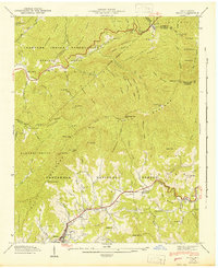
1942 Map of Addie
USGS Topo · Published 1942About this map
Sylva and the surrounding mountain ridges define the landscape of Jackson County in the early 1940s. The topography is dominated by the Plott Balsams, with high-elevation points like Waterrock Knob and Yellow Face overlooking the watershed. Along the valley floor, the Southern railroad parallels Scott Creek, serving as the primary transportation artery for small settlements such as Addie, Willits, and Hall. This corridor reflects the regional reliance on the rail network for moving goods and people through the difficult terrain of the Blue Ridge.
Find a feature on this map
95 named features on this map. Tap any name to fly to it.
Don’t see what you’re looking for? This feature index may not catch every label — zoom into the map to look around manually.
Map Details
Editions of this 1942 Addie Map
This is the sole edition of this map. No revisions or reprints were ever made.
Other maps of this area

1891 · Cowee
USGS Topo · 1:125,000

1893 · Mt Guyot
USGS Topo · 1:125,000

1897 · Cowee
USGS Topo · 1:125,000

1907 · Cowee
USGS Topo · 1:125,000

1912 · Mt Guyot
USGS Topo · 1:125,000

1933 · Bryson
USGS Topo · 1:62,500

1935 · Dellwood
USGS Topo · 1:24,000

1935 · Tuckaseigee
USGS Topo · 1:24,000

1935 · Hazelwood
USGS Topo · 1:24,000

1935 · Cullowhee
USGS Topo · 1:24,000