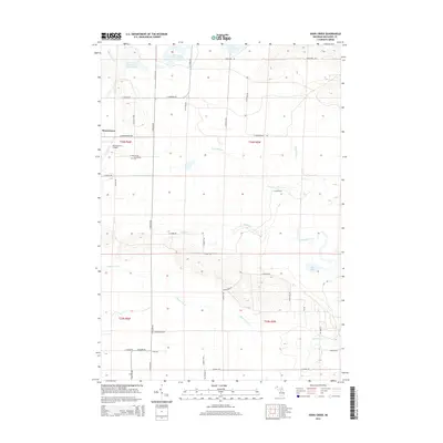
2014 Map of Addis Creek
USGS Topo · Published 2014About this map
Moorestown serves as the primary settlement hub in this northern Michigan landscape, where the local road network connects rural homesteads to the Moorestown Cem and the Moorestown Airpark. The terrain is defined by a complex hydrologic system, notably the expansive Dead Stream and the distinct water management areas of Big Cannon Creek Number One Flooding and Big Cannon Creek Number Two-Flooding in the northern reaches. These managed wetlands and seasonal flood zones suggest a history of conservation and wildlife habitat management within the forest. Several significant drainage systems, including Addis Cr, Haymarsh Cr, and Willow Run, wind through the township, interspersed with glacial features like Bear Lake and Grass Lake. The map reveals a land defined by its waters, where small rural roads like E Johnson Rd and N Nelson Rd navigate around low-lying marshlands and creek basins.
Find a feature on this map
40 named features on this map. Tap any name to fly to it.
Don’t see what you’re looking for? This feature index may not catch every label — zoom into the map to look around manually.
Map Details
Editions of this 2014 Addis Creek Map
This is the sole edition of this map. No revisions or reprints were ever made.
Other maps of this area

1949 · Fletcher
USGS Topo · 1:62,500

1950 · Cote Dame Marie
USGS Topo · 1:24,000

1950 · Fletcher
USGS Topo · 1:24,000

1954 · Traverse City
USGS Topo · 1:250,000

1956 · Kalkaska
USGS Topo · 1:62,500

1956 · Houghton Lake
USGS Topo · 1:62,500

1956 · Lake City
USGS Topo · 1:62,500

1958 · Traverse City
USGS Topo · 1:250,000

1983 · Cadillac
USGS Topo · 1:100,000
1983 · Meads Landing
USGS Topo · 1:25,000
Featured Places
- Enterprise Township, MI
- Norwich Township, MI
- West Branch Township, MI
- Missaukee County, MI
- United States