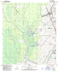
1992 Map of Addis
USGS Topo · Published 1992About this map
The Gulf Intracoastal Waterway cuts a distinct industrial path through this Louisiana landscape, where the energy sector and historic agricultural patterns converge. The Department of Energy Strategic Petroleum Reserve occupies a central position near the Bayou Choctaw Oil and Gas Field, illustrating the transition of the region into a critical energy hub during the late 20th century.
Find a feature on this map
46 named features on this map. Tap any name to fly to it.
Don’t see what you’re looking for? This feature index may not catch every label — zoom into the map to look around manually.
Map Details
Editions of this 1992 Addis Map
This is the sole edition of this map. No revisions or reprints were ever made.
Other maps of this area

1908 · Baton Rouge
USGS Topo · 1:62,500

1935 · Chicot Lake
USGS Topo · 1:62,500

1936 · White Castle
USGS Topo · 1:62,500

1939 · Baton Rouge
USGS Topo · 1:62,500

1940 · Grosse Tete
USGS Topo · 1:62,500

1953 · Baton Rouge West
USGS Topo · 1:24,000

1953 · Crescent
USGS Topo · 1:24,000

1953 · Plaquemine
USGS Topo · 1:24,000

1953 · Lobdell
USGS Topo · 1:24,000

1953 · Pigeon Bay
USGS Topo · 1:24,000