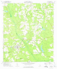
1974 Map of Adrian
USGS Topo · Published 1976About this map
The Ohoopee River winds through the borderlands of Johnson, Emanuel, and Treutlen Counties, shaping a landscape defined by its creek-fed bottomlands and early transport routes. Centered on the town of Adrian, the map captures the community as it appeared in the mid-1970s, with its High Sch and residential street grid positioned near the junction of several county lines. The geography here is heavily influenced by the heritage of the timber and rail industries, evidenced by the prominent Old Railroad Grade and Old RR Grade segments that cut through the terrain. To the east, Keas Old Millpond and the nearby Keas Ch Cems reflect the rural social hubs of the area. Further north, the settlement of Meeks sits near the crossing of Mulepen Creek, while various family-named landmarks like Pullen Bridge and Archers Pond dot the countryside.
Find a feature on this map
24 named features on this map. Tap any name to fly to it.
Don’t see what you’re looking for? This feature index may not catch every label — zoom into the map to look around manually.
Map Details
Editions of this 1974 Adrian Map
This is the sole edition of this map. No revisions or reprints were ever made.
Other maps of this area

1957 · Macon
USGS Topo · 1:250,000

1958 · Macon
USGS Topo · 1:250,000

1964 · Macon
USGS Topo · 1:250,000

1970 · Covena
USGS Topo · 1:24,000

1971 · Norristown
USGS Topo · 1:24,000

1971 · Soperton North
USGS Topo · 1:24,000

1971 · Dellwood
USGS Topo · 1:24,000

1971 · Rockledge
USGS Topo · 1:24,000

1974 · Kite
USGS Topo · 1:24,000

1974 · Wrightsville
USGS Topo · 1:24,000