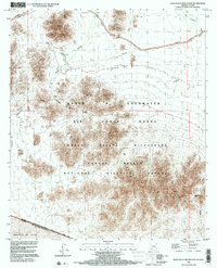
1996 Map of Agua Dulce Mountains
USGS Topo · Published 2000About this map
Agua Dulce Mountains dominate this arid landscape along the international border, where the rugged peaks of the Cabeza Prieta National Wildlife Refuge meet the restricted territory of the Barry M Goldwater Air Force Range. This 1996 compilation captures the intersection of conservation and military history in Pima County, showing a terrain marked by desert hydrology and early mineral exploration. The presence of features like Antelope Tank and the Agua Dulce Spring reveal the vital water sources that once supported travel through this harsh environment. To the south, the survey tracks the boundary between the United States of America and the Desierto de Altar in Sonora, Mexico. For those tracing the remnants of mining and ranching, the map identifies several scattered prospects, adits, and the Sapra Well Mine.
Find a feature on this map
29 named features on this map. Tap any name to fly to it.
Don’t see what you’re looking for? This feature index may not catch every label — zoom into the map to look around manually.
Map Details
Editions of this 1996 Agua Dulce Mountains Map
This is the sole edition of this map. No revisions or reprints were ever made.
Other maps of this area

1953 · Ajo
USGS Topo · 1:250,000

1954 · Sonoyta
USGS Topo · 1:250,000

1957 · Ajo
USGS Topo · 1:250,000

1958 · Ajo
USGS Topo · 1:250,000

1962 · Ajo
USGS Topo · 1:250,000

1963 · Ajo
USGS Topo · 1:250,000

1963 · Quitobaquito Springs
USGS Topo · 1:62,500

1963 · Lukeville
USGS Topo · 1:250,000
1964 · Agua Dulce Mts
USGS Topo · 1:62,500

1965 · O'Neill Hills
USGS Topo · 1:62,500