
1944 Map of Agua Dulce
USGS Topo · Published 1944About this map
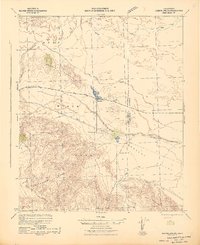
The Santa Rosa Mountains dominate the western landscape of this mid-century survey, rising sharply above the desert floor of the Coachella Valley. Along the eastern edge, the Salton Sea appears at a historic elevation of 241 feet below sea level, its shoreline dotted with early infrastructure like the Salton Sea Service Sta and Fish Springs. This area, primarily within the Torres Martines Indian Reservation, reflects a landscape defined by water scarcity and geological transition, from the Fossil Beds and Travertine Rock to the seasonal courses of Salada Wash and Gravel Wash.
Find a feature on this map
34 named features on this map. Tap any name to fly to it.
Don’t see what you’re looking for? This feature index may not catch every label — zoom into the map to look around manually.
Map Details
Editions of this 1944 Agua Dulce Map
This is the sole edition of this map. No revisions or reprints were ever made.
Other maps of this area

1904 · Indio
USGS Topo · 1:125,000

1931 · Vallecito
USGS Topo · 1:125,000

1939 · Borrego
USGS Topo · 1:62,500

1940 · Kane Spring
USGS Topo · 1:62,500

1940 · Cottonwood Spring
USGS Topo · 1:62,500

1940 · Durmid
USGS Topo · 1:62,500

1941 · Toro Peak
USGS Topo · 1:62,500

1941 · Clark Lake
USGS Topo · 1:62,500

1941 · Coachella
USGS Topo · 1:62,500
1942 · Barrel Spring
USGS Topo · 1:62,500