1942 Map of Barrel Spring
USGS Topo · Published 1942About this map
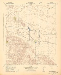
Anza State Park and the rugged basins of the Colorado Desert dominate this 1942 landscape during a period of expanding infrastructure. The settlement of Ocotillo serves as a central junction where Split Mountain Road meets the highway, while the smaller outpost of Little Borrego sits further south along the Old Kane Springs Road. This era reveals a desert economy driven by industrial extraction, evidenced by the Gypsum Mine in the south and the dedicated Pacific Portland Cement Railroad line used to transport raw materials across the arid flats.
Find a feature on this map
19 named features on this map. Tap any name to fly to it.
Don’t see what you’re looking for? This feature index may not catch every label — zoom into the map to look around manually.
Map Details
Editions of this 1942 Barrel Spring Map
2 editions found

Other maps of this area

1904 · Indio
USGS Topo · 1:125,000

1915 · El Centro
USGS Topo · 1:125,000

1931 · Vallecito
USGS Topo · 1:125,000

1931 · Carrizo
USGS Topo · 1:125,000

1939 · Borrego
USGS Topo · 1:62,500

1940 · Kane Spring
USGS Topo · 1:62,500

1940 · Plaster City
USGS Topo · 1:62,500

1940 · Durmid
USGS Topo · 1:62,500

1941 · Clark Lake
USGS Topo · 1:62,500

1942 · Agua Dulce
USGS Topo · 1:62,500