
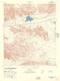
1940 Map of Durmid
USGS Topo · Published 1964About this map
The Salton Sea shoreline dominates this 1940s landscape, recorded shortly after the water surface was measured at 241 feet below sea level. Along the eastern shore, the Southern Pacific railroad serves a string of small desert outposts including Durmid and Bertram, while Salton Beach marks a rare point of shoreline development in Riverside County. Across the water in Imperial County, the landscape is defined by vast desert washes like Grave Wash and Tule Wash that cut toward the basin. The western edge of the map highlights early transit corridors through the arid terrain, specifically the Truckhaven Trail and the Anza Trail near the settlement of Truckhaven. This survey captures the region just as the Coachella Canal was being established on the eastern bluffs, a critical piece of water infrastructure that would eventually reshape the agricultural potential of the valley floor.
Find a feature on this map
22 named features on this map. Tap any name to fly to it.
Don’t see what you’re looking for? This feature index may not catch every label — zoom into the map to look around manually.
Map Details
Editions of this 1940 Durmid Map
This is the sole edition of this map. No revisions or reprints were ever made.
Other maps of this area

1904 · Indio
USGS Topo · 1:125,000

1931 · Vallecito
USGS Topo · 1:125,000

1940 · Kane Spring
USGS Topo · 1:62,500

1940 · Frink
USGS Topo · 1:62,500

1940 · Cottonwood Spring
USGS Topo · 1:62,500
1940 · Canyon Spring
USGS Topo · 1:62,500

1941 · Coachella
USGS Topo · 1:62,500
1942 · Barrel Spring
USGS Topo · 1:62,500

1942 · Agua Dulce
USGS Topo · 1:62,500

1943 · Vallecito
USGS Topo · 1:125,000