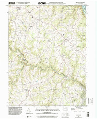
1999 Map of Airville
USGS Topo · Published 2002About this map
Muddy Creek carves a winding path through the heart of southern York County, defining a landscape of narrow valleys and rural settlements at the end of the twentieth century. The community of Airville sits atop the higher ground between the creek and the Susquehanna River, which forms the eastern boundary at Lake Aldred. This map documents a deeply rooted agricultural and institutional network, evidenced by numerous historical meeting houses and educational sites such as Guinston Ch, McKendree Ch, and Township Sch. Along the riverbank, the Indian Steps Museum stands as a notable cultural landmark near Bair Island. The concentration of named crossroads like Brogue, Collinsville, and Gatchellville illustrates a settlement pattern typical of the Pennsylvania Piedmont, where small villages served surrounding farmsteads. Significant conservation areas including State Game Lands No 83 and State Game Lands No 181 preserve the wooded slopes and runs that feed into the larger waterways.
Find a feature on this map
52 named features on this map. Tap any name to fly to it.
Don’t see what you’re looking for? This feature index may not catch every label — zoom into the map to look around manually.
Map Details
Editions of this 1999 Airville Map
This is the sole edition of this map. No revisions or reprints were ever made.
Other maps of this area

1900 · Parkton
USGS Topo · 1:62,500

1901 · Belair
USGS Topo · 1:62,500

1902 · Parkton
USGS Topo · 1:62,500

1908 · York
USGS Topo · 1:62,500

1910 · York
USGS Topo · 1:62,500

1912 · Mc Calls Ferry
USGS Topo · 1:62,500

1942 · Bel Air
USGS Topo · 1:62,500

1943 · Mc Calls Ferry
USGS Topo · 1:62,500

1944 · Norrisville
USGS Topo · 1:31,680

1945 · Bel Air
USGS Topo · 1:62,500
Featured Places
- Martic Township, PA
- East Hopewell Township, PA
- Lower Chanceford Township, PA
- Peach Bottom Township, PA
- Chanceford Township, PA