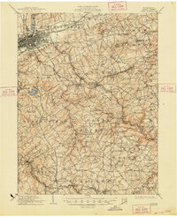
1908 Map of York
USGS Topo · Published 1963About this map
York and its surrounding townships at the dawn of the twentieth century reveal a landscape deeply integrated by rail and water power. The Northern Central RR and the York and Dallastown Electric Ry connect growing hubs like Red Lion and Dallastown, while industrial relics such as the Margaretta Furnace near the Cabin Creek drainage speak to the county's earlier iron-making history. Along the winding Codorus Creek, the York Water Co Pumping Station and Lake Williams show the development of early municipal infrastructure.
Find a feature on this map
135 named features on this map. Tap any name to fly to it.
Don’t see what you’re looking for? This feature index may not catch every label — zoom into the map to look around manually.
Map Details
Editions of this 1908 York Map
This is the sole edition of this map. No revisions or reprints were ever made.
Historical Maps of York Through Time
6 maps found