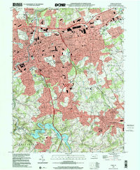
1999 Map of York
USGS Topo · Published 2001About this map
Codorus Creek flows through the heart of this landscape, anchoring a region defined by its dense suburban development and enduring industrial roots at the end of the millennium. The city of York serves as the central hub, with established neighborhoods like Elmwood and East York expanding outward toward the hills. This survey illustrates the complex transportation network of the era, from the historic Lincoln Highway and Susquehanna Trail to the modern series of interchanges along the primary north-south corridor.
Find a feature on this map
99 named features on this map. Tap any name to fly to it.
Don’t see what you’re looking for? This feature index may not catch every label — zoom into the map to look around manually.
Map Details
Editions of this 1999 York Map
This is the sole edition of this map. No revisions or reprints were ever made.
Other maps of this area

1906 · New Cumberland
USGS Topo · 1:62,500

1908 · Middletown
USGS Topo · 1:62,500

1908 · York
USGS Topo · 1:62,500

1910 · York
USGS Topo · 1:62,500

1920 · Hanover
USGS Topo · 1:62,500

1922 · Hanover
USGS Topo · 1:62,500

1943 · New Cumberland
USGS Topo · 1:62,500

1943 · Middletown
USGS Topo · 1:62,500

1948 · Baltimore
USGS Topo · 1:250,000

1950 · Harrisburg
USGS Topo · 1:250,000