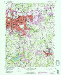
1954 Map of York
USGS Topo · Published 1990About this map
York serves as the dense urban anchor of this mid-century Pennsylvania landscape, where the Pennsylvania railroad and the Lincoln Highway intersect a complex network of industrial and residential growth. The city is surrounded by a ring of developing suburbs like East York and Wyndham Hills, while the outlying areas maintain a character defined by historical land use. To the south, the York-Reservoir and the expanse of Lake William H Kain illustrate the regional infrastructure, complemented by civic landmarks such as the County Home and York College. Significant genealogical and local history markers are visible throughout, including the sprawling Prospect Hill Cem and numerous country churches like Old Stonybrook Ch. The map also captures specialized industry through the Filtration Plant and Reynolds Mill, alongside mid-century cultural staples like the Drive-in Theater near Yorkshire.
Find a feature on this map
95 named features on this map. Tap any name to fly to it.
Don’t see what you’re looking for? This feature index may not catch every label — zoom into the map to look around manually.
Map Details
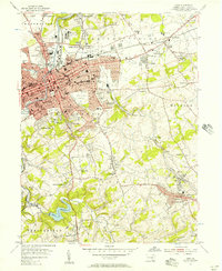
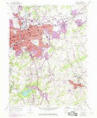
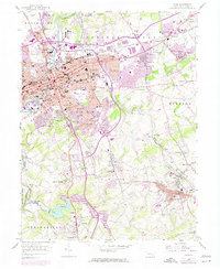
Editions of this 1954 York Map
4 editions found
Other maps of this area

1906 · New Cumberland
USGS Topo · 1:62,500

1908 · Middletown
USGS Topo · 1:62,500

1908 · York
USGS Topo · 1:62,500

1910 · York
USGS Topo · 1:62,500

1920 · Hanover
USGS Topo · 1:62,500

1922 · Hanover
USGS Topo · 1:62,500

1943 · New Cumberland
USGS Topo · 1:62,500

1943 · Middletown
USGS Topo · 1:62,500

1948 · Baltimore
USGS Topo · 1:250,000

1950 · Harrisburg
USGS Topo · 1:250,000