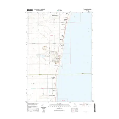
2014 Map of Alabaster
USGS Topo · Published 2014About this map
The coastal village of Alabaster and its surrounding township occupy this shoreline along Lake Huron, where the industrial character of the land meets residential beach communities. Large excavations near Gypsum Rd reflect the area’s long history of mineral extraction, which shaped the local economy and infrastructure. Along Us 23, a series of named residential developments such as Lake Huron Beach, Oak Wood Shores, and Cedar Haven line the coast, demonstrating the shift toward seasonal and permanent waterfront living. To the south, the terrain transitions into the forested lowlands of the Ipperwash Scarp, where the East Br Au Gres River and drainage networks like the Alabaster Whitney Drain define the landscape. Genealogists may find interest in the Alabaster Township Cem, located just inland from the lake, while landmarks like Alabaster Junction and Huron Oaks provide clear points for locating mid-century property and family homesteads.
Find a feature on this map
52 named features on this map. Tap any name to fly to it.
Don’t see what you’re looking for? This feature index may not catch every label — zoom into the map to look around manually.
Map Details
Editions of this 2014 Alabaster Map
This is the sole edition of this map. No revisions or reprints were ever made.
Other maps of this area

1954 · Tawas City
USGS Topo · 1:250,000

1958 · Tawas City
USGS Topo · 1:250,000

1959 · Tawas City
USGS Topo · 1:62,500

1959 · East Tawas
USGS Topo · 1:62,500

1966 · Point Lookout
USGS Topo · 1:24,000

1966 · Au Gres
USGS Topo · 1:24,000

1966 · Alabaster
USGS Topo · 1:24,000

1966 · National City
USGS Topo · 1:24,000
1970 · Charity Island
USGS Topo · 1:24,000

1984 · Tawas City
USGS Topo · 1:100,000