
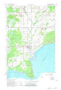
1966 Map of Au Gres
USGS Topo · Published 1968About this map
Au Gres sits at the meeting point of the Au Gres River and the expansive Saginaw Bay, serving as a hub for both agricultural and maritime activity in Arenac County. The landscape is defined by an intricate network of drainage systems, including Onion Drain and Bum Drain, which allowed for the development of townships like Whitney and Sims amidst the naturally wet terrain of Duck Lake Swamp and Gres Swamp. This mid-1960s survey captures the area’s rural character, showing isolated settlements such as Santiago and Delano, alongside local landmarks like the Riverside Ch and Linwood Cem. To the south, Point Au Gres marks a distinctive hook into the bay, while the presence of the Ogemaw State Forest and various quarries suggest a land tied to both timber and mineral extraction.
Find a feature on this map
69 named features on this map. Tap any name to fly to it.
Don’t see what you’re looking for? This feature index may not catch every label — zoom into the map to look around manually.
Map Details
Editions of this 1966 Au Gres Map
2 editions found
Other maps of this area

1954 · Flint
USGS Topo · 1:250,000

1954 · Tawas City
USGS Topo · 1:250,000

1958 · Flint
USGS Topo · 1:250,000

1958 · Tawas City
USGS Topo · 1:250,000

1966 · Point Lookout
USGS Topo · 1:24,000

1966 · Alabaster
USGS Topo · 1:24,000

1966 · National City
USGS Topo · 1:24,000
1967 · Standish NE
USGS Topo · 1:24,000

1968 · Whittemore
USGS Topo · 1:24,000
1968 · Omer
USGS Topo · 1:24,000