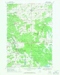
1968 Map of Omer
USGS Topo · Published 1971About this map
The Detroit and Mackinac railroad corridor anchors this mid-century view of Arenac County, connecting the small northern village of Twining to the city of Omer in the south. The landscape is defined by the winding course of the Tittabawassee River, which carves through the Tittabawassee River State Forest and creates unique landforms like Hickory Island. Beyond the riverbanks, the terrain transitions into the Tyler Plains, while the eastern portion of the map is dominated by the Duck Lake Swamp and various drainage networks including Chief Creek Drain and Cedar Creek Drain. Settlement patterns follow a strict grid of rural roads, such as Main Street Road and Bessinger Road, revealing the historical footprint of forestry and light industry, notably the Quarries located east of Omer. The Evergreen Cem stands as a permanent fixture on the landscape west of the river.
Find a feature on this map
44 named features on this map. Tap any name to fly to it.
Don’t see what you’re looking for? This feature index may not catch every label — zoom into the map to look around manually.
Map Details
Editions of this 1968 Omer Map
This is the sole edition of this map. No revisions or reprints were ever made.
Other maps of this area

1954 · Flint
USGS Topo · 1:250,000

1954 · Tawas City
USGS Topo · 1:250,000

1958 · Flint
USGS Topo · 1:250,000

1958 · Tawas City
USGS Topo · 1:250,000

1966 · Au Gres
USGS Topo · 1:24,000

1966 · National City
USGS Topo · 1:24,000
1967 · Standish NE
USGS Topo · 1:24,000
1967 · Standish
USGS Topo · 1:24,000

1968 · Prescott
USGS Topo · 1:24,000

1968 · Whittemore
USGS Topo · 1:24,000