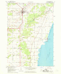
1967 Map of Standish
USGS Topo · Published 1969About this map
Standish serves as a central hub in the late 1960s, where the Penn Central and Detroit and Mackinac railroads intersect. This transit-oriented layout is complemented by the Standish City Airport and the County Fairground on the city's western edge. The landscape is defined by the drainage systems of the Pine River and the Saganing River, both of which flow eastward toward the shores of Saginaw Bay.
Find a feature on this map
49 named features on this map. Tap any name to fly to it.
Don’t see what you’re looking for? This feature index may not catch every label — zoom into the map to look around manually.
Map Details
Editions of this 1967 Standish Map
3 editions found
Other maps of this area

1954 · Traverse City
USGS Topo · 1:250,000

1954 · Midland
USGS Topo · 1:250,000

1954 · Flint
USGS Topo · 1:250,000

1954 · Tawas City
USGS Topo · 1:250,000

1958 · Traverse City
USGS Topo · 1:250,000

1958 · Flint
USGS Topo · 1:250,000

1958 · Tawas City
USGS Topo · 1:250,000

1958 · Midland
USGS Topo · 1:250,000

1959 · Midland
USGS Topo · 1:250,000

1966 · Midland
USGS Topo · 1:250,000