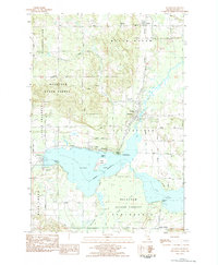
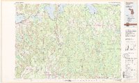
1983 Map of Alanson
USGS Topo · Published 1984About this map
Crooked Lake and the winding Crooked River define this Emmet County landscape during the early 1980s. The village of Alanson serves as a central hub, situated where the Michigan Northern railroad tracks cross the river. The surrounding shoreline is dotted with established lakefront communities including Oden, Ponshewaing, and Conway, each linked by the rail corridor and the North Michigan Road.
Find a feature on this map
46 named features on this map. Tap any name to fly to it.
Don’t see what you’re looking for? This feature index may not catch every label — zoom into the map to look around manually.
Map Details
Editions of this 1983 Alanson Map
This is the sole edition of this map. No revisions or reprints were ever made.
Other maps of this area

1955 · Cheboygan
USGS Topo · 1:250,000
1957 · Wolverine
USGS Topo · 1:62,500
1957 · Mullett Lake
USGS Topo · 1:62,500

1958 · Cheboygan
USGS Topo · 1:250,000
1958 · Pellston
USGS Topo · 1:62,500
1958 · Petoskey
USGS Topo · 1:62,500
1975 · Petoskey NW
USGS Topo · 1:24,000
1975 · Petoskey SW
USGS Topo · 1:24,000
1975 · Petoskey NE
USGS Topo · 1:24,000
1982 · Petoskey
USGS Topo · 1:100,000