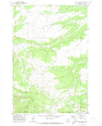
1970 Map of Alaska Bench
USGS Topo · Published 1973About this map
Alaska Bench dominates the high plains landscape of central Montana, where the foothills of the Snowy Mountains begin to rise out of the drainage basins. This 1970 survey captures a sparsely populated ranching and grazing region centered on the settlement of Holt, located near the convergence of several seasonal watercourses. The terrain is defined by dramatic elevation changes between the flat-topped benches and deep incisions like Horsethief Canyon and Maynard Coulee.
Find a feature on this map
21 named features on this map. Tap any name to fly to it.
Don’t see what you’re looking for? This feature index may not catch every label — zoom into the map to look around manually.
Map Details
Editions of this 1970 Alaska Bench Map
This is the sole edition of this map. No revisions or reprints were ever made.
Other maps of this area

1889 · Big Snowy Mountain
USGS Topo · 1:250,000

1893 · Big Snowy Mountain
USGS Topo · 1:250,000

1954 · Roundup
USGS Topo · 1:250,000

1958 · Roundup
USGS Topo · 1:250,000

1970 · Forestgrove
USGS Topo · 1:24,000

1970 · South Bench
USGS Topo · 1:24,000
1970 · Half Moon Canyon
USGS Topo · 1:24,000
1970 · Heath
USGS Topo · 1:24,000
1970 · Loco Ridge
USGS Topo · 1:24,000

1986 · Patterson Canyon
USGS Topo · 1:24,000