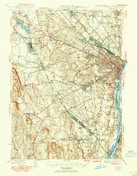
1950 Map of Albany
USGS Topo · Published 1950About this map
The Hudson River corridor serves as the industrial and transit spine of this 1950 revision, where the dense streets of Albany give way to a landscape defined by rail infrastructure and suburban growth. The massive Selkirk Yards and the Voorheesville Army Sub Depot illustrate the region's mid-century strategic importance as a logistics hub. Further west, the terrain rises sharply into the Helderberg Mountains, home to John Boyd Thacher Park, providing a stark contrast to the low-lying islands of the Hudson like Schermerhorn Island and Papsanee Island.
Find a feature on this map
108 named features on this map. Tap any name to fly to it.
Don’t see what you’re looking for? This feature index may not catch every label — zoom into the map to look around manually.
Map Details
Editions of this 1950 Albany Map
This is the sole edition of this map. No revisions or reprints were ever made.
Other maps of this area

1893 · Cohoes
USGS Topo · 1:62,500

1893 · Troy
USGS Topo · 1:62,500

1893 · Schenectady
USGS Topo · 1:62,500

1893 · Coxsackie
USGS Topo · 1:62,500

1893 · Durham
USGS Topo · 1:62,500

1893 · Albany
USGS Topo · 1:62,500

1894 · Coxsackie
USGS Topo · 1:62,500

1894 · Durham
USGS Topo · 1:62,500

1895 · Troy
USGS Topo · 1:62,500

1895 · Cohoes
USGS Topo · 1:62,500