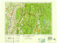
1959 Map of Albany
USGS Topo · Published 1959About this map
The Hudson River and Connecticut River valleys dominate this regional study, which captures the industrial and hydrological landscape of the Northeast in the late 1950s. The map illustrates a complex network of water management, from the massive Quabbin Reservoir in Massachusetts to the Sacandaga Reservoir in New York, alongside numerous smaller basins like the Cobble Mt Reservoir and Barkhamsted Reservoir. This era shows the established dominance of the New York Central and Boston and Maine railroads, even as the New York State Thruway appears as a modern transportation corridor. Mountainous terrain is clearly defined, including the Green Mountains and the Catskill Mountains, providing a detailed look at the geographic barriers that shaped the development of regional centers like Albany, Springfield, and Pittsfield.
Find a feature on this map
90 named features on this map. Tap any name to fly to it.
Don’t see what you’re looking for? This feature index may not catch every label — zoom into the map to look around manually.
Map Details
Editions of this 1959 Albany Map
This is the sole edition of this map. No revisions or reprints were ever made.
Other maps of this area

1885 · Northampton
USGS Topo · 1:62,500
1885 · Sheffield
USGS Topo · 1:62,500

1885 · Worcester
USGS Topo · 1:62,500

1886 · Greylock
USGS Topo · 1:62,500

1886 · Springfield
USGS Topo · 1:62,500

1886 · Hawley
USGS Topo · 1:62,500

1886 · Chesterfield
USGS Topo · 1:62,500

1886 · Worcester
USGS Topo · 1:62,500

1886 · Northampton
USGS Topo · 1:62,500
1886 · Becket
USGS Topo · 1:62,500