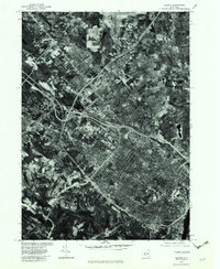
1978 Map of Albany
USGS Topo · Published 1982About this map
Albany is captured here during the late 1970s, revealing a landscape defined by the convergence of major transportation corridors and dense suburban expansion. The orthophotoquad format, produced from aerial photography taken in 1978, provides a starkly different perspective than traditional line maps, showing the actual footprints of commercial centers, residential neighborhoods, and the industrial infrastructure along the eastern edge near Rensselaer. The winding course of Normans Kill provides a natural contrast to the geometric patterns of modern development in Delmar and Slingerlands. North of the city center, the growth of communities like Colonie, Loudonville, and Latham is visible as they fill the space between the radial highways. This survey, rectified by the Geological Survey in cooperation with the Soil Conservation Service, offers genealogists and local historians an exact record of the capital region's built environment before the further intensifications of the late twentieth century.
Find a feature on this map
10 named features on this map. Tap any name to fly to it.
Don’t see what you’re looking for? This feature index may not catch every label — zoom into the map to look around manually.
Map Details
Editions of this 1978 Albany Map
This is the sole edition of this map. No revisions or reprints were ever made.
Other maps of this area

1893 · Cohoes
USGS Topo · 1:62,500

1893 · Troy
USGS Topo · 1:62,500

1893 · Schenectady
USGS Topo · 1:62,500

1893 · Albany
USGS Topo · 1:62,500

1895 · Troy
USGS Topo · 1:62,500

1895 · Cohoes
USGS Topo · 1:62,500

1895 · Albany
USGS Topo · 1:62,500

1895 · Schenectady
USGS Topo · 1:62,500

1898 · Schenectady
USGS Topo · 1:62,500

1898 · Albany
USGS Topo · 1:62,500