
Loading...
Loading map...1985 Map of Albert Lea
USGS Topo · Published 1985About this map
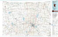
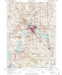
Albert Lea serves as the focal point for this Southern Minnesota landscape during the mid-1980s, situated at the intersection of a complex hydrographic and transportation network. The map reveals an extensive system of agricultural drainage, documented through numerous labels like Judicial Ditch No 7 and County Ditch No 20, which transformed the prairie wetlands into productive farmland. The drainage patterns surround natural water bodies such as Geneva Lake and Freeborn Lake, highlighting the managed nature of the regional water table.
Find a feature on this map
118 named features on this map. Tap any name to fly to it.
Don’t see what you’re looking for? This feature index may not catch every label — zoom into the map to look around manually.
Map Details
Date Portrayed1985
Date Published1985
PublisherU.S. Geological Survey
Map TypeTopographic
Scale1:100,000
Physical Dimensions21.53 x 27.23 inches
Editions of this 1985 Albert Lea Map
2 editions found
Historical Maps of Austin Through Time
Featured Locations
Source Details
SourceU.S. Geological Survey
CopyrightPublic Domain