1958 Map of Albuquerque
USGS Topo · Published 1958About this map
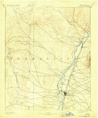
Mount Taylor dominates the western horizon of this mid-century survey, anchoring a landscape where ancient indigenous settlements and modern scientific research facilities coexist. The Rio Grande corridor serves as the primary artery for growth, linking the expanding city of Albuquerque with historic sites such as Santo Domingo Pueblo and San Felipe Pueblo. This era reflects a significant transition in land use, as traditional ranching and farming areas around Bernalillo and Corrales began to interface with federal installations like Sandia Base and Kirtland Air Force Base.
Find a feature on this map
157 named features on this map. Tap any name to fly to it.
Don’t see what you’re looking for? This feature index may not catch every label — zoom into the map to look around manually.
Map Details
Editions of this 1958 Albuquerque Map
This is the sole edition of this map. No revisions or reprints were ever made.
Historical Maps of Albuquerque Through Time
8 maps found