
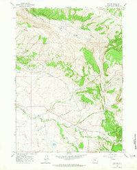
1950 Map of Alcova SE
USGS Topo · Published 1971About this map
The North Platte River winds through the northwestern corner of this high-plains landscape, where the early energy industry left its mark on the Natrona County terrain. By the mid-20th century, extractive operations like the Spindle Top Oil Field and Bolton Creek Oil Field were already noted as inactive, reflecting a shift in the local economy. The area is defined by a series of drainages, including Stinking Creek and the branching system of Bolton Creek, which feed into the wider basin of Bates Hole. Transportation across these hills relied on a network of functional routes such as Top Spindle Road and an established Stock Trail, while isolated resources like the Bolton Artesian Well provided critical water access in a region primarily used for grazing and resource extraction.
Find a feature on this map
18 named features on this map. Tap any name to fly to it.
Don’t see what you’re looking for? This feature index may not catch every label — zoom into the map to look around manually.
Map Details
Editions of this 1950 Alcova SE Map
This is the sole edition of this map. No revisions or reprints were ever made.
Other maps of this area

1950 · Alcova
USGS Topo · 1:24,000

1951 · Clarkson Hill
USGS Topo · 1:24,000

1951 · Bessemer Mountain
USGS Topo · 1:24,000

1951 · Bear Mountain
USGS Topo · 1:24,000

1951 · Bear Spring
USGS Topo · 1:24,000

1955 · Casper
USGS Topo · 1:250,000

1958 · Casper
USGS Topo · 1:250,000

1960 · Twin Buttes
USGS Topo · 1:24,000

1960 · Horse Peak
USGS Topo · 1:24,000
1960 · Freeland
USGS Topo · 1:24,000