
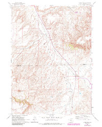
1960 Map of Horse Peak
USGS Topo · Published 1964About this map
Bates Hole dominates this interior Wyoming landscape, where the high desert terrain transitions toward the elevations of Chalk Mountain and Horse Peak. This 1960 survey documents a ranching environment defined by wide spacing between operations like Body Ranch and Kirk Ranch, reflecting the scale of land required for livestock in this arid territory. The drainage system is particularly distinct, with Stinking Creek cutting through the central basin and Lone Tree Creek following the contours of the southern hills. Positioned along the border of Natrona and Carbon Counties, the map details a network of unimproved dirt roads and light-duty paths that connected these remote homesteads to distant hubs like Casper. The presence of numerous named springs, such as those feeding Lawn Creek, illustrates the critical importance of water sources for both the survival of the ranches and the movement of cattle across the open range.
Find a feature on this map
16 named features on this map. Tap any name to fly to it.
Don’t see what you’re looking for? This feature index may not catch every label — zoom into the map to look around manually.
Map Details
Editions of this 1960 Horse Peak Map
2 editions found
Other maps of this area

1950 · Alcova SE
USGS Topo · 1:24,000

1951 · Bear Mountain
USGS Topo · 1:24,000

1953 · Fourmile Point
USGS Topo · 1:24,000

1955 · Casper
USGS Topo · 1:250,000

1958 · Casper
USGS Topo · 1:250,000

1960 · Twin Buttes
USGS Topo · 1:24,000

1960 · Wild Irish Reservoir
USGS Topo · 1:24,000

1960 · Sheep Creek
USGS Topo · 1:24,000

1960 · Mud Springs
USGS Topo · 1:24,000

1960 · Measel Spring Reservoir
USGS Topo · 1:24,000