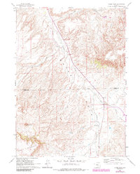
1960 Map of Horse Peak
USGS Topo · Published 1985About this map
Bates Hole defines this central Wyoming landscape, where the high-plains topography drops into a complex basin of drainages and ranch lands. Situated at the boundary of Natrona and Carbon counties, the area is anchored by the prominent Horse Peak and the southern rise of Chalk Mountain. This 1960 survey, updated in the mid-1980s, captures the remote ranching operations of the era, such as Body Ranch and Kirk Ranch, which are connected by a network of seasonal watercourses including Stinking Creek, Lawn Creek, and Elk Creek. The map provides a detailed view of the rural infrastructure before modern development, marking the long stretches of Bolton Creek Road and the significant distance to Medicine Bow. The terrain is characterized by intricate contouring that illustrates the erosion patterns of the basins and the steep ascents of the surrounding peaks.
Find a feature on this map
13 named features on this map. Tap any name to fly to it.
Don’t see what you’re looking for? This feature index may not catch every label — zoom into the map to look around manually.
Map Details
Editions of this 1960 Horse Peak Map
2 editions found
Other maps of this area

1950 · Alcova SE
USGS Topo · 1:24,000

1951 · Bear Mountain
USGS Topo · 1:24,000

1953 · Fourmile Point
USGS Topo · 1:24,000

1955 · Casper
USGS Topo · 1:250,000

1958 · Casper
USGS Topo · 1:250,000

1960 · Twin Buttes
USGS Topo · 1:24,000

1960 · Wild Irish Reservoir
USGS Topo · 1:24,000

1960 · Horse Peak
USGS Topo · 1:24,000

1960 · Sheep Creek
USGS Topo · 1:24,000

1960 · Mud Springs
USGS Topo · 1:24,000