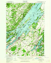
1948 Map of Alexandria Bay
USGS Topo · Published 1964About this map
St Lawrence River defines the landscape of this 1948 survey, separating the rural townships of Alexandria and Orleans from Ontario's Front of Yonge and Lansdowne. The waterway is a maze of named islands including Wellesley Island, Tar Island, and Grenadier Island, connected by the Thousand Island Bridge corridor. On the New York shore, the village of Alexandria Bay serves as a hub for the river economy, while inland, smaller agricultural centers like Redwood and Plessis are surrounded by a dense network of numbered schoolhouses and small lakes such as Butterfield Lake and Mud Lake.
Find a feature on this map
113 named features on this map. Tap any name to fly to it.
Don’t see what you’re looking for? This feature index may not catch every label — zoom into the map to look around manually.
Map Details
Editions of this 1948 Alexandria Bay Map
2 editions found

Other maps of this area

1900 · Clayton
USGS Topo · 1:62,500

1903 · Grindstone
USGS Topo · 1:62,500

1903 · Clayton
USGS Topo · 1:62,500

1903 · Alexandria Bay
USGS Topo · 1:62,500

1903 · Theresa
USGS Topo · 1:62,500

1906 · Brier Hill
USGS Topo · 1:62,500

1911 · Antwerp
USGS Topo · 1:62,500

1912 · Hammond
USGS Topo · 1:62,500

1942 · Clayton
USGS Topo · 1:24,000

1942 · Morristown
USGS Topo · 1:24,000