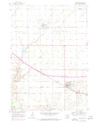
1957 Map of Alexandria
USGS Topo · Published 1977About this map
Alexandria and Fulton serve as the primary hubs in this Hanson County landscape, anchored by a dual-railroad network that shaped local commerce. The Chicago and North Western passes through Fulton in the north, while the Chicago Milwaukee St Paul and Pacific cuts diagonally through the center toward Alexandria. This transport infrastructure is mirrored by a rural social fabric of township schools and cemeteries, including St Marys Cem and Green Hill Cem near the county seat.
Find a feature on this map
21 named features on this map. Tap any name to fly to it.
Don’t see what you’re looking for? This feature index may not catch every label — zoom into the map to look around manually.
Map Details
Editions of this 1957 Alexandria Map
2 editions found
Other maps of this area

1899 · Alexandria
USGS Topo · 1:125,000

1955 · Sioux Falls
USGS Topo · 1:250,000

1957 · Alexandria
USGS Topo · 1:24,000

1957 · Ethan
USGS Topo · 1:24,000

1957 · Rockport Colony
USGS Topo · 1:24,000

1957 · Riverside
USGS Topo · 1:24,000

1957 · Farwell
USGS Topo · 1:24,000

1958 · Sioux Falls
USGS Topo · 1:250,000

1973 · Spencer SW
USGS Topo · 1:24,000

1973 · Ness Chain Lakes
USGS Topo · 1:24,000
Featured Places
- Alexandria, SD
- Fulton, SD
- Rosedale Hutterite Colony, SD
- Millbrook Hutterite Colony, SD
- Wayne Township, SD