
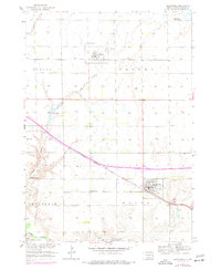
1957 Map of Alexandria
USGS Topo · Published 1958About this map
The prairie landscape of Hanson County is defined by the intersection of rail and water in the late 1950s. Alexandria sits at the crossing of Chicago Milwaukee St Paul and Pacific and Pierre Creek, while to the north, Fulton serves as a hub for the Chicago and North Western line. This survey captures a moment of transition for rural infrastructure, specifically noting several educational sites as decommissioned, including School No 1 (Abandoned) and School No 4 (Abandoned). The southern edge of the map follows the winding course of the James River near the Rosedale Colony, where the terrain begins to shift toward the river valley. Local history and genealogy are anchored by several established burial grounds such as Graceland Cem and Green Hill Cem, providing clear reference points for the mid-century township boundaries of Hanson, Jasper, and Rosedale.
Find a feature on this map
23 named features on this map. Tap any name to fly to it.
Don’t see what you’re looking for? This feature index may not catch every label — zoom into the map to look around manually.
Map Details
Editions of this 1957 Alexandria Map
2 editions found
Other maps of this area

1899 · Alexandria
USGS Topo · 1:125,000

1955 · Sioux Falls
USGS Topo · 1:250,000

1957 · Ethan
USGS Topo · 1:24,000

1957 · Rockport Colony
USGS Topo · 1:24,000

1957 · Riverside
USGS Topo · 1:24,000

1957 · Farwell
USGS Topo · 1:24,000

1958 · Sioux Falls
USGS Topo · 1:250,000

1973 · Spencer SW
USGS Topo · 1:24,000

1973 · Ness Chain Lakes
USGS Topo · 1:24,000

1973 · Farmer
USGS Topo · 1:24,000
Featured Places
- Alexandria, SD
- Fulton, SD
- Rosedale Hutterite Colony, SD
- Millbrook Hutterite Colony, SD
- Wayne Township, SD