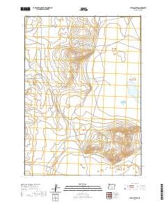
2020 Map of Alkali Buttes
USGS Topo · Published 2020About this map
Alkali Buttes rise as a prominent landform in this high desert region of Lake County, where the topography is defined by significant volcanic features and seasonal basins. This survey captures the isolated terrain of southeastern Oregon as documented by the U.S. Geological Survey using data from 1899 to 2019. The landscape is characterized by the expansive depression of North Alkali Lake, a dry lake bed located at the eastern edge of the quadrangle. A network of unimproved roads and 4WD trails navigates the surrounding flats and cinder cones, reflecting a remote environment largely under public land management. The grid of the Public Land Survey System, including t29s r23e, structures this open territory where natural landmarks serve as the primary points of orientation.
Find a feature on this map
8 named features on this map. Tap any name to fly to it.
Don’t see what you’re looking for? This feature index may not catch every label — zoom into the map to look around manually.
Map Details
Editions of this 2020 Alkali Buttes Map
This is the sole edition of this map. No revisions or reprints were ever made.
Other maps of this area

1955 · Crescent
USGS Topo · 1:250,000

1955 · Klamath Falls
USGS Topo · 1:250,000

1955 · Burns
USGS Topo · 1:250,000

1955 · Adel
USGS Topo · 1:250,000

1957 · Adel
USGS Topo · 1:250,000

1957 · Crescent
USGS Topo · 1:250,000

1958 · Crescent
USGS Topo · 1:250,000

1958 · Klamath Falls
USGS Topo · 1:250,000

1958 · Burns
USGS Topo · 1:250,000

1958 · Adel
USGS Topo · 1:250,000