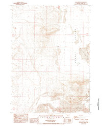
1984 Map of Alkali Buttes
USGS Topo · Published 1984About this map
Alkali Valley dominates this high desert landscape in Lake County, Oregon, revealing a terrain defined by arid basins and prominent volcanic outcrops. At the southern end of the sheet, the Alkali Buttes rise sharply above the valley floor, providing a stark vertical contrast to the sprawling Sand Dunes that shift across the eastern flats. Water is a scarce and vital resource here, marked primarily by the presence of North Alkali Lake and human-made infrastructure like the Three Corners Well. The map captures a moment in the early 1980s when the region remained largely undeveloped, characterized by a grid of township and range lines that slice through the open basin. This survey serves as a clear record of the geological and hydraulic features of a remote Oregon playa before modern environmental changes.
Find a feature on this map
8 named features on this map. Tap any name to fly to it.
Don’t see what you’re looking for? This feature index may not catch every label — zoom into the map to look around manually.
Map Details
Editions of this 1984 Alkali Buttes Map
This is the sole edition of this map. No revisions or reprints were ever made.
Other maps of this area

1955 · Crescent
USGS Topo · 1:250,000

1955 · Klamath Falls
USGS Topo · 1:250,000

1955 · Burns
USGS Topo · 1:250,000

1955 · Adel
USGS Topo · 1:250,000

1957 · Adel
USGS Topo · 1:250,000

1957 · Crescent
USGS Topo · 1:250,000

1958 · Crescent
USGS Topo · 1:250,000

1958 · Klamath Falls
USGS Topo · 1:250,000

1958 · Burns
USGS Topo · 1:250,000

1958 · Adel
USGS Topo · 1:250,000