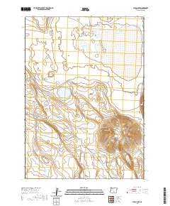
2020 Map of Alkali Lake
USGS Topo · Published 2020About this map
Venator Butte rises above the high desert landscape of Lake County, Oregon, defining the topography of this arid quadrangle. The 2020 survey illustrates a sparsely populated region where water sources are vital yet suggestively named, including Horror Spring, Hutton Spring, and the isolated Nasty Pond. These names reflect the harsh realities of the terrain for early surveyors and travelers. The land is organized by the Public Land Survey System, with boundaries such as t30s r23e and t31s r23e segmenting the open space.
Find a feature on this map
10 named features on this map. Tap any name to fly to it.
Don’t see what you’re looking for? This feature index may not catch every label — zoom into the map to look around manually.
Map Details
Editions of this 2020 Alkali Lake Map
This is the sole edition of this map. No revisions or reprints were ever made.
Other maps of this area

1955 · Crescent
USGS Topo · 1:250,000

1955 · Klamath Falls
USGS Topo · 1:250,000

1955 · Burns
USGS Topo · 1:250,000

1955 · Adel
USGS Topo · 1:250,000

1957 · Adel
USGS Topo · 1:250,000

1957 · Crescent
USGS Topo · 1:250,000

1958 · Crescent
USGS Topo · 1:250,000

1958 · Klamath Falls
USGS Topo · 1:250,000

1958 · Burns
USGS Topo · 1:250,000

1958 · Adel
USGS Topo · 1:250,000