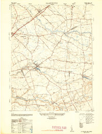
1948 Map of Allentown
USGS Topo · Published 1948About this map
Allentown serves as the central hub of this agricultural and residential landscape in the late 1940s, situated at the intersection of several regional routes and defined by its proximity to Conines Millpond. The map reveals a high concentration of named corners and crossroads, such as Pages Corner, Eilers Corner, and Cooleys Corner, which suggest a long-established pattern of local land ownership. Significant social and industrial infrastructure is visible, including Doctor Farmers Hospital, the Allentown Water Works, and the Trenton-Robbinsville Airport to the northwest. The terrain is drained by a network of waterways including Assunpink Creek and Doctors Creek, which historically supported milling operations at sites like Kirbys Mills and Homes Mills. Special-use facilities like Greyhound Kennels and Nelson Nurseries highlight the varied economic activity of the area during this post-war period.
Find a feature on this map
72 named features on this map. Tap any name to fly to it.
Don’t see what you’re looking for? This feature index may not catch every label — zoom into the map to look around manually.
Map Details
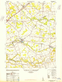
Editions of this 1948 Allentown Map
2 editions found
Other maps of this area

1888 · Bordentown
USGS Topo · 1:62,500

1888 · New Brunswick
USGS Topo · 1:62,500

1888 · Princeton
USGS Topo · 1:62,500

1888 · Cassville
USGS Topo · 1:62,500

1893 · Bordentown
USGS Topo · 1:62,500

1893 · New Brunswick
USGS Topo · 1:62,500

1894 · Princeton
USGS Topo · 1:62,500

1894 · Cassville
USGS Topo · 1:62,500

1900 · Cassville
USGS Topo · 1:62,500

1901 · New Brunswick
USGS Topo · 1:62,500
Featured Places
- Hamilton Township, NJ
- East Windsor Township, NJ
- West Windsor, NJ
- Robbinsville Township, NJ
- Millstone Township, NJ