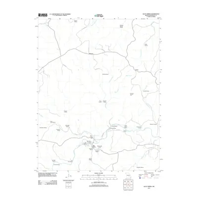
2011 Map of Alley Spring
USGS Topo · Published 2011About this map
The Alley Mill stands as a focal point along the waters of Alley Spring and the Jacks Fork river in this 2011 Missouri survey. This area of Shannon County is defined by a dense network of topographic hollows, including Bullock Hollow and Possum Trot Hollow, which channel water toward the central river system. The settlement of Alley and the nearby Alley Spring Campground highlight the importance of this specific hydrology for both early industry and modern recreation. The map also documents scattered rural communities such as Flatwood and Venice, connected by winding county roads. For those researching family history, the Grassy Hollow Cemetery and Culpepper Cemetery provide critical spatial context for local residents, while landmarks like Grandma Rocks and the Eminence Landing Strip ground the landscape in specific local naming traditions and infrastructure.
Find a feature on this map
54 named features on this map. Tap any name to fly to it.
Don’t see what you’re looking for? This feature index may not catch every label — zoom into the map to look around manually.
Map Details
Editions of this 2011 Alley Spring Map
This is the sole edition of this map. No revisions or reprints were ever made.
Other maps of this area

1915 · Eminence
USGS Topo · 1:62,500

1917 · Eminence
USGS Topo · 1:62,500

1932 · Cedar Grove
USGS Topo · 1:48,000

1945 · Round Spring
USGS Topo · 1:62,500

1946 · Summersville
USGS Topo · 1:62,500

1947 · Sinkin
USGS Topo · 1:48,000

1948 · Summersville
USGS Topo · 1:62,500

1949 · Round Spring
USGS Topo · 1:62,500

1949 · Rolla
USGS Topo · 1:250,000
1951 · Lewis Hollow
USGS Topo · 1:24,000