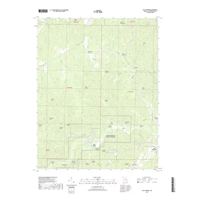
2017 Map of Alley Spring
USGS Topo · Published 2017About this map
Jacks Fork winds through the heart of the Ozark National Scenic Riverway, carving a deep network of drainages across Shannon County. The settlement of Alley Spring serves as a focal point near the river's bend, where the landscape is defined by an intricate system of hollows with descriptive local names like Possum Trot Hollow, Pistol Barrel Hollow, and Kingfisher Hollow. These narrow valleys suggest a history of isolated homesteads and specific geographical landmarks used by generations of residents.
Find a feature on this map
70 named features on this map. Tap any name to fly to it.
Don’t see what you’re looking for? This feature index may not catch every label — zoom into the map to look around manually.
Map Details
Editions of this 2017 Alley Spring Map
This is the sole edition of this map. No revisions or reprints were ever made.
Other maps of this area

1915 · Eminence
USGS Topo · 1:62,500

1917 · Eminence
USGS Topo · 1:62,500

1932 · Cedar Grove
USGS Topo · 1:48,000

1945 · Round Spring
USGS Topo · 1:62,500

1946 · Summersville
USGS Topo · 1:62,500

1947 · Sinkin
USGS Topo · 1:48,000

1948 · Summersville
USGS Topo · 1:62,500

1949 · Round Spring
USGS Topo · 1:62,500

1949 · Rolla
USGS Topo · 1:250,000
1951 · Lewis Hollow
USGS Topo · 1:24,000