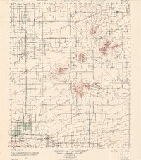
1947 Map of Alpine Butte
USGS Topo · Published 1947About this map
Isolated peaks and agricultural ranching developments define the High Desert landscape of the Antelope Valley in the late 1940s. The prominent Alpine Butte and Piute Butte rise sharply from the valley floor, creating landmarks for the surrounding homesteads and small settlements. Near the center of the sheet, the Antelope Valley Indian Museum sits near the Rocky Buttes, preserving regional cultural history during an era of expanding rural desert life.
Find a feature on this map
19 named features on this map. Tap any name to fly to it.
Don’t see what you’re looking for? This feature index may not catch every label — zoom into the map to look around manually.
Map Details
Editions of this 1947 Alpine Butte Map
This is the sole edition of this map. No revisions or reprints were ever made.
Other maps of this area

1900 · Tujunga
USGS Topo · 1:62,500

1901 · Southern California Sheet No. 1
USGS Topo · 1:250,000

1903 · Rock Creek
USGS Topo · 1:62,500

1903 · San Antonio
USGS Topo · 1:62,500

1904 · Southern California Sheet No. 1
USGS Topo · 1:250,000

1915 · Elizabeth Lake
USGS Topo · 1:125,000

1917 · Elizabeth Lake
USGS Topo · 1:125,000

1930 · Joshua
USGS Topo · 1:24,000

1930 · Lovejoy Springs
USGS Topo · 1:24,000

1930 · Black Butte
USGS Topo · 1:24,000