
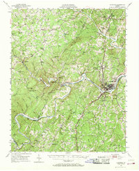
1951 Map of Altavista
USGS Topo · Published 1953About this map
The Roanoke River and the Virginian railroad corridor define this 1950s landscape where Campbell, Bedford, and Pittsylvania counties meet. The industrial hub of Altavista sits at a strategic bend in the river, connected by rail to outlying stations like Lynch Sta and Otterwood Sta. The surrounding rural Piedmont is densely settled with small communities and family landmarks, including Boneytown, Huddleston, and Mentow. Local social life of the era is preserved through numerous named country churches such as Bethlehem Ch and Mt Horeb Ch, alongside rural schoolhouses like Greasy Sch and Hurt Sch. The terrain is marked by prominent elevations like King George Mtn and Jasper Mtn, while the Pigg River flows through the southern reaches near Coles Quarter. This survey captures the region just before significant modern development, showing traditional water features like Preston Mill Pond still central to the local geography.
Find a feature on this map
87 named features on this map. Tap any name to fly to it.
Don’t see what you’re looking for? This feature index may not catch every label — zoom into the map to look around manually.
Map Details
Editions of this 1951 Altavista Map
2 editions found
Other maps of this area

1890 · Roanoke
USGS Topo · 1:125,000

1891 · Roanoke
USGS Topo · 1:125,000

1892 · Lynchburg
USGS Topo · 1:125,000

1921 · Chatham
USGS Topo · 1:48,000

1922 · Callands
USGS Topo · 1:48,000

1923 · Chatham
USGS Topo · 1:62,500

1924 · Callands
USGS Topo · 1:62,500

1944 · Lynchburg
USGS Topo · 1:62,500

1944 · Callands
USGS Topo · 1:62,500

1947 · Roanoke
USGS Topo · 1:250,000