1951 Map of Altavista
USGS Topo · Published 1968About this map
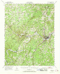
Altavista and the surrounding river valley are defined by the convergence of major transportation lines and the winding course of the Roanoke River. This mid-century survey captures the industrial and agricultural hub where the Southern and Virginian railroads meet, facilitating the growth of settlements like Hurt and Lynch Sta. The landscape is a mix of small village centers and high topographic relief, with Johnson Mtn and Scott Mtn rising above the watershed of the Big Otter River.
Find a feature on this map
104 named features on this map. Tap any name to fly to it.
Don’t see what you’re looking for? This feature index may not catch every label — zoom into the map to look around manually.
Map Details
Editions of this 1951 Altavista Map
2 editions found

Other maps of this area

1890 · Roanoke
USGS Topo · 1:125,000

1891 · Roanoke
USGS Topo · 1:125,000

1892 · Lynchburg
USGS Topo · 1:125,000

1921 · Chatham
USGS Topo · 1:48,000

1922 · Callands
USGS Topo · 1:48,000

1923 · Chatham
USGS Topo · 1:62,500

1924 · Callands
USGS Topo · 1:62,500

1944 · Lynchburg
USGS Topo · 1:62,500

1944 · Callands
USGS Topo · 1:62,500

1947 · Roanoke
USGS Topo · 1:250,000