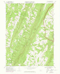
1967 Map of Amaranth
USGS Topo · Published 1973About this map
Addison Ridge and Rays Hill dominate this landscape on the border of Bedford and Fulton Counties, where a series of steep, parallel ridges defines the drainage patterns of the Ridge and Valley province. Small agricultural pockets and cross-road settlements like Amaranth and Silver Mills are tucked into the valleys, connected by winding roads that negotiate the gaps. The map reveals an extraction-based economy with numerous Gas Wells dotted along Pole Ridge and Hoop Pole Ridge, while large tracts are preserved as State Game Lands No 49 and the Buchanan State Forest. Genealogists will find several rural landmarks of interest, including Wards Ch, Shreves Chapel, and isolated burial sites such as the Shreves Cem. The presence of distinctive terrain features like The Lockings and McKees Gap illustrates the topographical constraints that have shaped local settlement since the mid-20th century.
Find a feature on this map
50 named features on this map. Tap any name to fly to it.
Don’t see what you’re looking for? This feature index may not catch every label — zoom into the map to look around manually.
Map Details
Editions of this 1967 Amaranth Map
4 editions found
Other maps of this area

1898 · Paw Paw
USGS Topo · 1:62,500

1899 · Hancock
USGS Topo · 1:62,500

1900 · Pawpaw
USGS Topo · 1:62,500

1901 · Hancock
USGS Topo · 1:62,500

1910 · Paw Paw
USGS Topo · 1:62,500

1925 · Needmore
USGS Topo · 1:48,000

1927 · Clearville
USGS Topo · 1:48,000

1931 · Clearville
USGS Topo · 1:62,500

1935 · Needmore
USGS Topo · 1:62,500

1939 · Needmore
USGS Topo · 1:62,500
Featured Places
- Bethel Township, PA
- Union Township, PA
- Mann Township, PA
- Brush Creek Township, PA
- Point View, Union Township