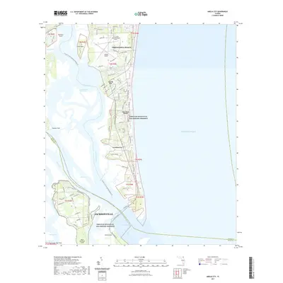
2021 Map of Amelia City
USGS Topo · Published 2021About this map
Amelia Island serves as the primary focal point of this coastal survey, where the barrier island's development meets the preservation efforts of the Timucuan Ecological and Historic Preserve. The northern portion of the map is anchored by the southern extent of Fernandina Beach and its Fernandina Beach Municipal Airport, transitioning southward into settlements like Amelia City, American Beach, and Franklintown. These communities are bound by a complex network of waterways, including the Intracoastal Waterway and the South Amelia River, which weave through Mesa Marsh. As the island reaches its southern tip at Nassau Sound, the map shows the northern edge of Jacksonville and the protected lands of Talbot Island. This 2021 update illustrates the modern road network, including Buccaneer Trl, alongside recreational corridors like the Florida Circumnavigational Paddling Trl.
Find a feature on this map
78 named features on this map. Tap any name to fly to it.
Don’t see what you’re looking for? This feature index may not catch every label — zoom into the map to look around manually.
Map Details
Editions of this 2021 Amelia City Map
This is the sole edition of this map. No revisions or reprints were ever made.
Other maps of this area

1918 · St Marys
USGS Topo · 1:62,500

1918 · Jacksonville
USGS Topo · 1:62,500

1918 · Mayport
USGS Topo · 1:62,500

1919 · Fernandina
USGS Topo · 1:62,500

1919 · St Marys
USGS Topo · 1:62,500

1944 · Fernandina
USGS Topo · 1:62,500

1948 · Jacksonville
USGS Topo · 1:250,000

1948 · Eastport
USGS Topo · 1:24,000
1950 · Mayport
USGS Topo · 1:24,000
1950 · Eastport
USGS Topo · 1:24,000