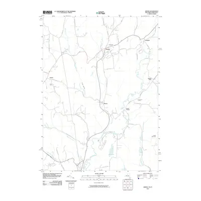
2010 Map of Amenia
USGS Topo · Published 2010About this map
Amenia and Wassaic serve as the primary hubs in this corner of Dutchess County, situated where the valley floor meets the rising terrain of Turkey Hollow and Cobble Mountain. The landscape is defined by the winding paths of Webatuck Creek and the Tenmile River, which anchor a series of small, dispersed settlements like South Amenia and Amenia Union on the Connecticut border. Local history is preserved in the Amenia Island Cemetery and South Amenia Cemetery, while the presence of named agricultural sites such as Evergreen Farm reflects the area's enduring rural character. The road network, including the historic Shunpike Rd and Leedsville Rd, connects these older hamlets across a topography marked by significant features like Deep Hollow and Mutton Hollow. This survey captures the transition from established village centers to the quiet, creek-fed hollows that have shaped the region's development for generations.
Find a feature on this map
58 named features on this map. Tap any name to fly to it.
Don’t see what you’re looking for? This feature index may not catch every label — zoom into the map to look around manually.
Map Details
Editions of this 2010 Amenia Map
This is the sole edition of this map. No revisions or reprints were ever made.
Other maps of this area

1892 · Cornwall
USGS Topo · 1:62,500

1892 · New Milford
USGS Topo · 1:62,500

1893 · New Milford
USGS Topo · 1:62,500

1893 · Cornwall
USGS Topo · 1:62,500

1893 · Clove
USGS Topo · 1:62,500

1894 · Clove
USGS Topo · 1:62,500

1898 · Clove
USGS Topo · 1:62,500

1899 · Millbrook
USGS Topo · 1:62,500

1901 · Clove
USGS Topo · 1:62,500

1902 · Millbrook
USGS Topo · 1:62,500