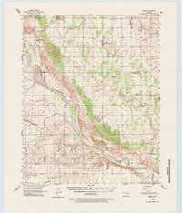
1956 Map of Ames
USGS Topo · Published 1984About this map
Ames anchors the northern reaches of this mid-century survey, situated along the ST Louis San Francisco railroad line where it crosses Hoyle Creek. The landscape is defined by the wide, shifting course of the Cimarron River, which cuts diagonally through the territory, flanked by numerous smaller tributaries like Spring Creek and Squaw Creek. This era reveals a rural society transitioning from the prominence of one-room schoolhouses to larger districts, evidenced by the presence of Dunbar Sch (Abandoned) and the Mound Ridge Sch. Scattered rural centers such as Lacey and Barr appear alongside numerous community landmarks, including the Cimarron Valley Cem and Antioch Ch. The southern portion reflects a growing petroleum interest, with Oil Well locations appearing near the river's edge, contrasting with established farming communities like East Cooper.
Find a feature on this map
45 named features on this map. Tap any name to fly to it.
Don’t see what you’re looking for? This feature index may not catch every label — zoom into the map to look around manually.
Map Details
Editions of this 1956 Ames Map
2 editions found
Other maps of this area

1892 · Kingfisher
USGS Topo · 1:125,000

1893 · Hennessey
USGS Topo · 1:62,500

1893 · Loyal
USGS Topo · 1:62,500

1893 · Ames
USGS Topo · 1:62,500

1895 · Kingfisher
USGS Topo · 1:125,000

1954 · Oklahoma City
USGS Topo · 1:250,000

1955 · Clinton
USGS Topo · 1:250,000

1955 · Enid
USGS Topo · 1:250,000

1955 · Woodward
USGS Topo · 1:250,000

1956 · Ames
USGS Topo · 1:62,500