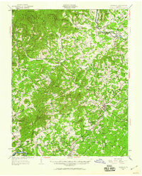
1950 Map of Amherst
USGS Topo · Published 1960About this map
The George Washington National Forest dominates the western half of this landscape, where the Appalachian Trail traverses ridges between Cowcamp Gap and Bald Knob. This mid-century survey captures the rural character of the Piedmont and Blue Ridge foothills, centered on the town of Amherst. The Southern railroad corridor anchors the eastern settlements, passing through the campus of Sweet Briar College and the community of Monroe. The map reveals a dense network of local landmarks, including several general stores like Dodds Store and Henleys Store, which served as vital hubs for mountain residents. Moving away from the forest peaks like High Peak, the terrain gives way to agriculture and small community centers marked by institutions such as the Indian Mission and the Chestnut Grove Sch. The junction of the Piney River and Buffalo River defines the northern boundary, reflecting the region's reliance on these watercourses for industry and settlement.
Find a feature on this map
86 named features on this map. Tap any name to fly to it.
Don’t see what you’re looking for? This feature index may not catch every label — zoom into the map to look around manually.
Map Details
Editions of this 1950 Amherst Map
This is the sole edition of this map. No revisions or reprints were ever made.
Other maps of this area

1892 · Lynchburg
USGS Topo · 1:125,000

1892 · Buckingham
USGS Topo · 1:125,000

1892 · Appomattox
USGS Topo · 1:125,000

1894 · Lexington
USGS Topo · 1:125,000

1932 · Lexington
USGS Topo · 1:48,000

1935 · Buena Vista
USGS Topo · 1:48,000

1935 · Amherst
USGS Topo · 1:48,000

1936 · Vesuvius
USGS Topo · 1:48,000

1937 · Lexington
USGS Topo · 1:62,500

1939 · Amherst
USGS Topo · 1:62,500