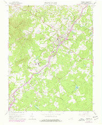
1963 Map of Amherst
USGS Topo · Published 1978About this map
Sweet Briar College and its surrounding agricultural and institutional lands anchor this portion of Amherst County, as it appeared in the early 1960s with 1970s updates. The landscape is defined by the Southern railroad corridor, which links the county seat at Amherst to smaller trackside points like Sweet Briar Station and Monroe. This map reveals a community organized around rural educational and religious centers, featuring landmarks such as the Amherst Training Sch, Central High Sch, and Ebenezer Ch. Significant water systems, including the Buffalo River and Rutledge Creek, weave between topographic highs like Richardson Mountain and Kentucky Mountain. The 1978 photorevision identifies shifting development patterns and industrial features, including a Quarry and Filtration Plant, alongside long-standing family locations like the Williams Cem and Faulconer Cem.
Find a feature on this map
59 named features on this map. Tap any name to fly to it.
Don’t see what you’re looking for? This feature index may not catch every label — zoom into the map to look around manually.
Map Details
Editions of this 1963 Amherst Map
Other maps of this area

1892 · Lynchburg
USGS Topo · 1:125,000

1892 · Buckingham
USGS Topo · 1:125,000

1892 · Appomattox
USGS Topo · 1:125,000

1894 · Lexington
USGS Topo · 1:125,000

1935 · Amherst
USGS Topo · 1:48,000

1939 · Amherst
USGS Topo · 1:62,500

1944 · Lynchburg
USGS Topo · 1:62,500

1947 · Roanoke
USGS Topo · 1:250,000

1950 · Amherst
USGS Topo · 1:62,500

1950 · Lynchburg
USGS Topo · 1:62,500