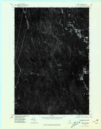
1975 Map of Amity NW
USGS Topo · Published 1980About this map
The dense forests of Aroostook County dominate this orthophotograph, captured in the mid-1970s. The landscape is defined by the isolated patterns of rural Maine living, where clearings for agriculture and residential plots emerge suddenly from the timberland. Wilcox Settlement and Estabrook Settlement represent the primary pockets of human activity, situated along thin access roads that cut through the woods. Near the center of the quadrangle, the dark waters of Elevenmile Lake sit surrounded by marshy wetlands and dense tree cover. This imagery provides an unfiltered view of the land's texture, showing exactly how timber harvesting and small-scale farming shaped the terrain before more modern developments altered the rural character of the region.
Find a feature on this map
3 named features on this map. Tap any name to fly to it.
Don’t see what you’re looking for? This feature index may not catch every label — zoom into the map to look around manually.
Map Details
Editions of this 1975 Amity NW Map
This is the sole edition of this map. No revisions or reprints were ever made.
Other maps of this area

1937 · Smyrna Mills
USGS Topo · 1:62,500

1938 · Houlton
USGS Topo · 1:62,500

1940 · Amity
USGS Topo · 1:62,500

1941 · Amity
USGS Topo · 1:62,500

1941 · Mattawamkeag Lake
USGS Topo · 1:62,500

1943 · Amity
USGS Topo · 1:62,500

1943 · Mattawamkeag Lake
USGS Topo · 1:62,500

1951 · Houlton
USGS Topo · 1:62,500

1954 · Presque Isle
USGS Topo · 1:250,000

1954 · Millinocket
USGS Topo · 1:250,000