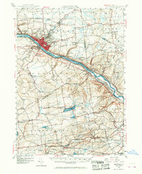
1947 Map of Amsterdam
USGS Topo · Published 1968About this map
The Mohawk River corridor dominates this landscape, serving as a vital industrial and transportation artery where the Erie Canal and major rail lines converge. Industrial activity is centered in Amsterdam, which spreads along both banks of the river, while smaller settlements like Fort Johnson and Hagaman dot the northern hills. The map illustrates a complex transit network just after the mid-century, showing the New York Central and Hudson River RR and West Shore RR paralleling the water, alongside the developing New York State Thruway with its early interchanges. To the south, the terrain rises toward Mariaville Lake and the agricultural lands of Duanesburg, where landmarks like the Duanesburg Airport and Sky Haven Airport represent the era's growing local aviation infrastructure. This survey captures a moment when traditional river-town industry met the burgeoning age of the interstate highway.
Find a feature on this map
106 named features on this map. Tap any name to fly to it.
Don’t see what you’re looking for? This feature index may not catch every label — zoom into the map to look around manually.
Map Details
Editions of this 1947 Amsterdam Map
3 editions found
Other maps of this area

1893 · Schenectady
USGS Topo · 1:62,500

1893 · Albany
USGS Topo · 1:62,500

1895 · Albany
USGS Topo · 1:62,500

1895 · Schenectady
USGS Topo · 1:62,500

1895 · Amsterdam
USGS Topo · 1:62,500

1896 · Fonda
USGS Topo · 1:62,500

1898 · Schenectady
USGS Topo · 1:62,500

1898 · Albany
USGS Topo · 1:62,500

1898 · Fonda
USGS Topo · 1:62,500

1898 · Schoharie
USGS Topo · 1:62,500