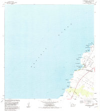
1982 Map of Anaehoomalu
USGS Topo · Published 1982About this map
Puuwaawaa Lava Flow of 1859 and the Puu Anahulu Lava Flow of 1859 dominate the Kohala and Kona coastal landscape, illustrating the raw volcanic history of the Big Island. Along the rugged shoreline, ancient and modern land uses converge at Anaehoomalu, where the Kuualii Fishpond and Kahapapa Fishpond remain as prominent landmarks. This era shows the interface between traditional coastal settlements like Lahuipua'a and the emerging infrastructure of the late twentieth century.
Find a feature on this map
35 named features on this map. Tap any name to fly to it.
Don’t see what you’re looking for? This feature index may not catch every label — zoom into the map to look around manually.
Map Details
Editions of this 1982 Anaehoomalu Map
2 editions found
Other maps of this area

1913 · Kohala
USGS Topo · 1:62,500

1916 · Kohala
USGS Topo · 1:62,500

1928 · Puako
USGS Topo · 1:62,500

1954 · Hawaii North
USGS Topo · 1:250,000

1956 · Puu Hinai
USGS Topo · 1:24,000

1956 · Kawaihae
USGS Topo · 1:24,000

1959 · Hawaii North
USGS Topo · 1:250,000

1959 · Kiholo
USGS Topo · 1:24,000
1959 · Anaehoomalu
USGS Topo · 1:24,000

1959 · Makalawena
USGS Topo · 1:24,000