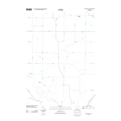
2013 Map of Anamosa NE
USGS Topo · Published 2013About this map
Downers Grove and the surrounding township lands of Cass and Jackson define this portion of Jones County in the early 21st century. The landscape is carved by a dendritic drainage pattern, where Buffalo Cr and its tributaries, including Helmer Cr, wind through the sectioned agricultural grid. The map reveals the persistence of early transit corridors and local landmarks, such as Old Cass Rd and Old Church Rd, which trace the historical development of these rural communities. The intersection of county routes like Co RD-x31 and Co Road e16 illustrates the modern infrastructure supporting the area's agricultural economy. This survey documents the precise locations of small settlements and named waterways like Deer Cr and Kitty Cr, providing a clear record of the spatial relationship between the land and the people of eastern Iowa.
Find a feature on this map
48 named features on this map. Tap any name to fly to it.
Don’t see what you’re looking for? This feature index may not catch every label — zoom into the map to look around manually.
Map Details
Editions of this 2013 Anamosa NE Map
This is the sole edition of this map. No revisions or reprints were ever made.
Other maps of this area

1890 · Anamosa
USGS Topo · 1:62,500

1891 · Monticello
USGS Topo · 1:62,500

1900 · Anamosa
USGS Topo · 1:125,000

1959 · Dubuque
USGS Topo · 1:250,000

1961 · Dubuque
USGS Topo · 1:250,000

1962 · Dubuque
USGS Topo · 1:250,000

1966 · Hopkinton East
USGS Topo · 1:24,000
1973 · Prairieburg
USGS Topo · 1:24,000
1973 · Springville
USGS Topo · 1:24,000
1973 · Anamosa
USGS Topo · 1:24,000