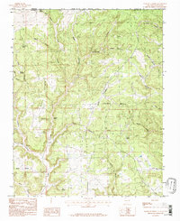
1985 Map of Anastacio Spring
USGS Topo · Published 1985About this map
Anastacio Spring and other vital water sources like Beef Spring and Barrel Spring define this high-altitude landscape along the border of the Southern Ute Indian Reservation Boundary. Mapping during the mid-1980s reveals a terrain dominated by deeply incised drainages, including Devils Canyon, Albino Canyon, and Simon Canyon. The area is marked by a network of unimproved roads and a distinctive Trail system, suggesting a region primarily utilized for livestock grazing and resource management rather than dense settlement. Notable landmarks such as Devils Washpan and the elevated reach of Pump Mesa stand out among the various pockets and glades. The map also records the jurisdictional transition between La Plata County, Colorado, and San Juan County, New Mexico, capturing a remote corner of the Four Corners region where natural geography dictates the pace of movement.
Find a feature on this map
33 named features on this map. Tap any name to fly to it.
Don’t see what you’re looking for? This feature index may not catch every label — zoom into the map to look around manually.
Map Details
Editions of this 1985 Anastacio Spring Map
This is the sole edition of this map. No revisions or reprints were ever made.
Other maps of this area

1889 · Largo
USGS Topo · 1:250,000

1895 · Largo
USGS Topo · 1:250,000

1908 · Ignacio
USGS Topo · 1:125,000

1924 · Ignacio
USGS Topo · 1:125,000

1945 · Durango
USGS Topo · 1:250,000

1953 · Durango
USGS Topo · 1:250,000

1954 · Durango
USGS Topo · 1:250,000

1954 · Pine River
USGS Topo · 1:24,000
1954 · Burnt Mesa
USGS Topo · 1:24,000

1954 · Aztec
USGS Topo · 1:250,000